Liberty Bell Trail
North Penn Region - Make YOUR Voice Heard!
Liberty Bell Trail Updates & Maps
- Liberty Bell Trail Update - July 21, 2021
- Liberty Bell Trail Study Franconia Township, Souderton Borough And Telford Borough Display Board
- Liberty Bell Trail Study Hatfield Township, Hatfield Borough And Lansdale Borough Display Board
- Liberty Bell Trail Study Upper Gwynedd Township, Lansdale Boroughand North Wales Borough Display Board
- Liberty Bell Trail Feasibility Study (Mont Co.) Final Report March 2022

The Liberty Bell Trail in North Penn
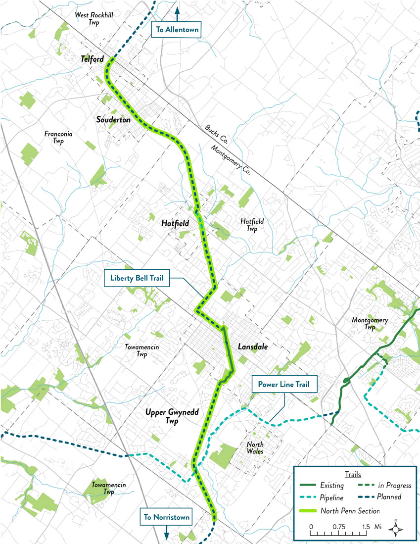
The Liberty Bell Trail (LBT) in North Penn will link residents and visitors alike to downtown centers; residential neighborhoods; parks, libraries, and schools; natural areas and open spaces; transportation hubs; and much, much more.
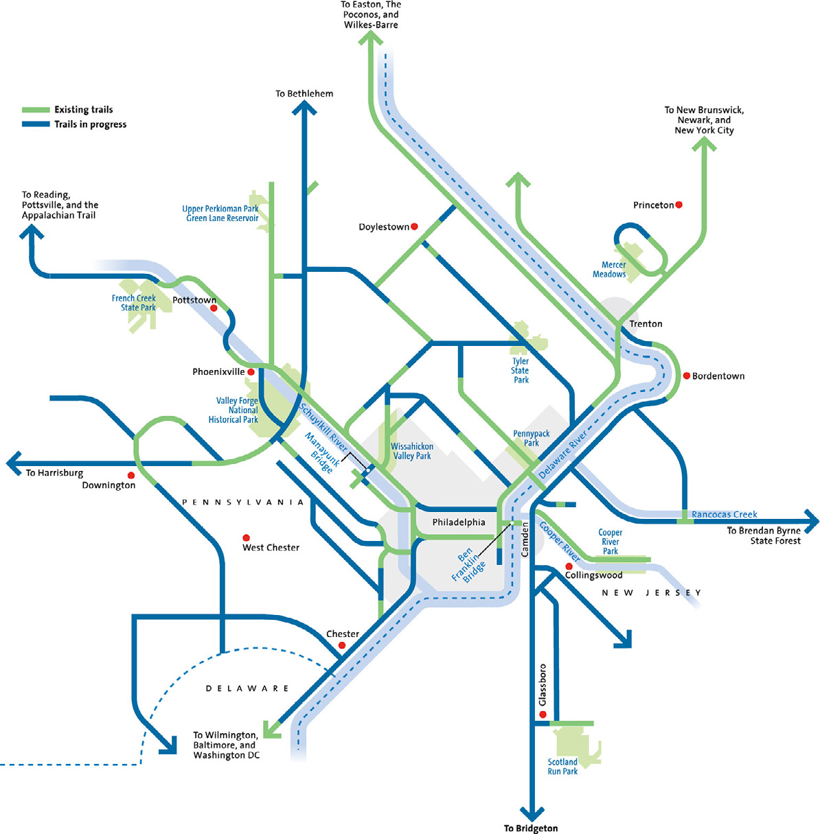
In addition to local connections, the LBT will connect into the broader network of Circuit Trails, the Philadelphia region’s growing trail network.
In North Penn, the LBT will intersect with the Powerline Trail, which moves from east to west across Montgomery County and beyond. The Powerline Trail will provide residents with access to Evansburg State Park, as well as Bucks County to the northeast. To the south, in Norristown, PA, the LBT will eventually link into the Schuylkill River Trail, creating connections with Philadelphia, Valley Forge, and Reading, PA!
Where would YOU like the Liberty Bell Trail to take you? Let us know by filling out this survey.
The Circuit Trails
The Liberty Bell Trail is part of the Circuit Trails, a network of 800+ miles of trails (~350 miles currently built) throughout the Philadelphia region.
The Circuit makes our region stronger by providing a place for healthy transportation and recreation, connecting our communities to green space, and making our neighborhoods more attractive places to live and work. Once fully connected, the Circuit Trails will be one of the nation’s premier urban trail networks.
The Circuit provides endless opportunities for recreating and commuting. So whether you bike it, walk it, or run it, the point is — just enjoy it.
History of the Liberty Bell Trail Corridor
The LBT corridor has been nearly 250 years in the making. The path was first tread by a few brave colonists just before the British Army invaded Philadelphia, who carried the Liberty Bell out of Philadelphia to safety in Allentown, Pennsylvania.

Figure 1-historical depiction of the Liberty Bell being moved out of Philadelphia.
In the early 1900s, as Philadelphia and its suburbs were rapidly expanding, the historic route colonists used to rescue the Liberty Bell over 100 years earlier was converted into the Liberty Bell Trolley Line.

Figure 2-the Liberty Bell Trolley line used to run through the study area; few pieces of the ROW remain.
As the use of automobiles became increasingly widespread from the 1920s-on, the Liberty Bell Trolley saw fewer and fewer passengers until 1951, when the Liberty Bell Trolley line ceased operations.
The Current Study
Eight municipalities in Montgomery County are collaborating with the Pennsylvania Environmental Council and consulting firm Michael Baker International to advance the planning of the Liberty Bell Trail (LBT). Those municipalities include Upper Gwynedd Township, North Wales Borough, Lansdale Borough, Hatfield Township, Hatfield Borough, Franconia Township, Souderton Borough and Telford Borough. A prior LBT Feasibility Study completed in 2005 investigated the potential development of the former 25-mile Liberty Bell Trolley route between Norristown and Quakertown into a trail network for walking and bicycling.
This feasibility study will focus on the 11-mile portion of the LBT in Montgomery County. Over the past 16 years, some progress has been made toward its completion, including construction of approximately 1.5 miles in Lansdale Borough and another half mile in Hatfield Borough. As part of this trail update, we will investigate changes that have occurred along the planned trail route, explore alternatives, and make recommendations for a preferred alignment. These technical tasks will be supported by a robust public outreach program using numerous virtual and traditional techniques. The study is anticipated to be completed by early 2022.
How Can I Make MY Voice Heard?
How can YOU get involved in the Montgomery County Liberty Bell Trail feasibility study? One thing you can do is participate in the WikiMap and fill out the associated survey. That said, the most important thing you can do to push the Liberty Bell Trail forward is reaching out to your elected officials to express your support for the Liberty Bell Trail. Township staff and administration will be responsible for seeking funding to put this feasibility study into action, and they need to know their constituents are in support!
If you would like to stay up to date on upcoming public meetings and events, be sure to check out our webpage. Email Zhenya Nalywayko (Znalywayko@pecpa.org) if you would like to be placed on our mailing list. Thank you for your support!
Links:
- WikiMap & Survey: https://wikimapping.com/Liberty-Bell-Trail.html
- Pennsylvania Environmental Council LBT Webpage: https://pecpa.org/program/liberty-bell-trail/
- Zhenya “Z” Nalywayko email address: Znalywayko@pecpa.org

